A data-backed look at eight intersections across the Puget Sound that keep appearing in crash studies, safety audits and redesign plans.
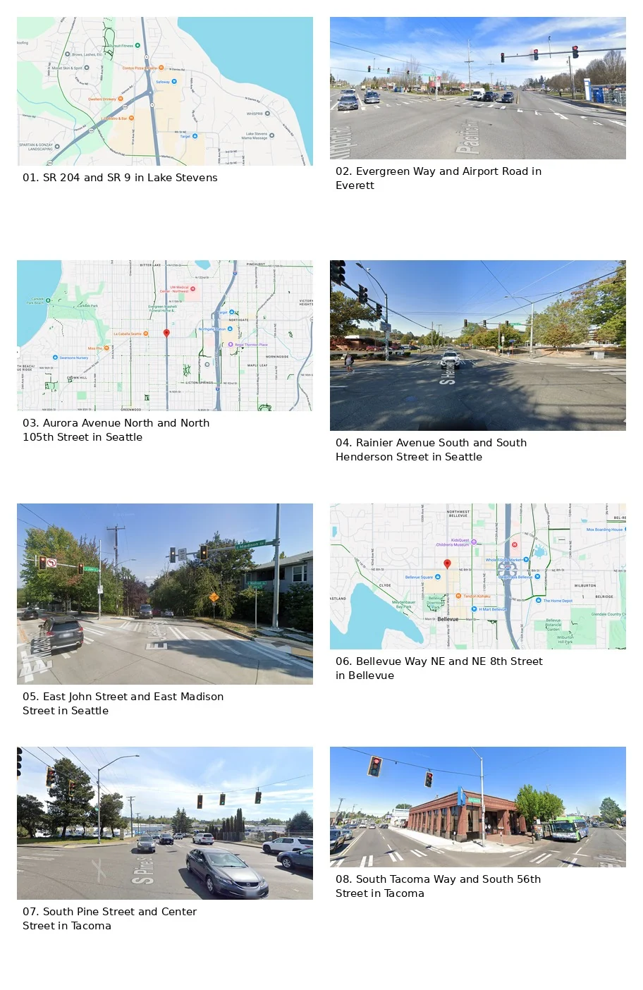
1) SR 204 and SR 9 in Lake Stevens
This one belongs on any serious list. A 2026 study that says it analyzed Washington State Patrol collision data from 2021 through 2024 called the SR 204 and SR 9 roundabout the most crash-prone intersection in Washington, with 272 crashes over that span. WSDOT also treated this as a major problem area, eventually rebuilding it with four roundabouts and widening work in a $69 million project that finished in 2025.
What makes it bad is not hard to picture. It carries regional traffic, freight, shopping traffic, and a lot of local turning movements all in one place. Even after a redesign meant to improve flow and safety, it is still the kind of intersection people in Snohomish County talk about by name.
2) Evergreen Way and Airport Road in Everett
This Everett intersection is more than just busy. It has also stood out for the seriousness of the crashes there. The same 2026 Washington intersection study found that Highway 99/Evergreen Way and Airport Road had the highest severity rating among the intersections it identified, with three fatalities and five serious injuries over four years. That tracks with concerns the city of Everett has raised itself. In 2022, the city reported that the stretch of Evergreen Way between Airport Road and Everett Mall Way had the highest injury crash rate —and the highest pedestrian injury crash rate— of any arterial segment in Everett.
That matters because this is not some isolated corner. It sits on a fast, commercial stretch where drivers, turning traffic, transit riders, and pedestrians all collide with a street design that long favored speed over comfort.
3) Aurora Avenue North and North 105th Street in Seattle
Aurora has a reputation, and the data backs up why. INRIX reported that the most crashes by total count in its Seattle intersection analysis happened near Aurora Ave N and N 105th St. Separately, SDOT has been blunt that Aurora has a history of safety challenges, and the city has rolled out pedestrian-first signals, crosswalk work, sidewalk upgrades, and planned no-turn-on-red restrictions along the corridor.
In plain English, this is the kind of place where a lot is happening at once and the street still asks too much of everybody. Drivers are moving fast, crossings are long, and small mistakes stop being small pretty quickly.
4) Rainier Avenue South and South Henderson Street in Seattle
Rainier and Henderson is exactly the kind of South Seattle intersection that ends up on safety planners’ radar for good reason. SDOT says S Henderson Street had 71 police-reported crashes from 2018 to 2022, including five serious injuries. The city specifically added no-turn-on-red signs at Rainier Ave S and S Henderson St as part of its school-safety work in the area. Rainier from S Kenny St to S Henderson St is also part of Seattle’s ongoing Phase 2 safety work on the corridor.
This one matters because it is not just about drivers. The intersection serves schools, buses, apartments, businesses, and daily foot traffic. When a place is used that heavily, weak design choices show up fast.
5) East John Street and East Madison Street in Seattle
Not every dangerous intersection looks like a freeway ramp. Some are messy because the geometry is awkward and the conflict points pile up. INRIX said E John Street and E Madison Street had the highest crash rate per 100,000 vehicles in its Seattle analysis. SDOT has also been making safety upgrades in that same E John / E Madison / 24th Ave E area through the Madison corridor work, including a new crosswalk, a raised crosswalk, a curb bulb, and wider sidewalk space for safer crossings.
That is usually a sign agencies already know an intersection asks people to make too many judgment calls in too little space. And that is often where crashes happen.
6) Bellevue Way NE and NE 8th Street in Bellevue
Bellevue Way and NE 8th is one of the clearest examples of an intersection making a safety list because a city has already studied it in depth. Bellevue used this intersection for a pedestrian-detection pilot, and its before-and-after crosswalk study says the location was chosen because it has high vehicle and pedestrian volumes. The city then found that after installing high-visibility crosswalks, the vehicle-pedestrian conflict rate dropped 56%.
That is a pretty strong clue that this was not a random spot. Bellevue’s broader Vision Zero work also says most fatal and serious injury crashes happen on a relatively small High Injury Network, and NE 8th has been one of the corridors studied through that program.
7) South Pine Street and Center Street in Tacoma
Tacoma’s own Road Safety Audit for South Pine put this intersection in unusually direct language: it called S Pine St and Center St the intersection of two high-risk Vision Zero corridors. Tacoma has also kept Pine Street between Center Street and South 47th Street in active planning for pedestrian and bicycle safety improvements.
That tells you this is not just a place locals complain about. It is a place the city itself has already tagged as part of a bigger pattern of serious risk.
8) South Tacoma Way and South 56th Street in Tacoma
South Tacoma Way and South 56th is another one that keeps surfacing in Tacoma planning and safety work. City planning documents say Tacoma began using video analytics at this intersection to record traffic movements, including near misses, so staff could redesign the area more intelligently. The city’s South Tacoma plan also specifically prioritizes Road Safety Audit work in the South Tacoma Way business district / South 56th Street area. On top of that, Tacoma still has a red-light camera at S 56th Street and S Tacoma Way.
You do not usually bring out near-miss analytics, corridor redesign talk, and automated enforcement at the same spot unless there is a real problem to solve.
Why These Intersections Keep Showing Up
There is a pattern here. These are not sleepy residential four-ways. They are places where fast arterials meet heavy turning traffic, transit, retail driveways, schools, freight, or long pedestrian crossings. That does not excuse bad driving. It just means the road itself leaves less room for mistakes.
And that is the real story across the Puget Sound. A lot of the worst intersections are not “bad” because one driver did something dumb on one day. They are bad because the design, speed, and volume create the same conflicts over and over again.

Join the Conversation
Comments are moderated before publication. Keep it relevant, civil, and respectful of the people involved.